The free MGRS app for iPhone and Android
MilMap shows your own position live in MGRS, lets you enter and convert grid coordinates, and keeps working offline in the field. Downloading and using it costs nothing.
Free Starter plan — no credit card required
or use it in your browser — Open the web app
What exactly is free?
MGRS is part of the free Starter plan — not behind a trial or a paywall. Here is what you get without paying, and what needs a paid plan.
Included in Starter (free)
- Display and enter MGRS coordinates
- Your own position live in MGRS
- Up to 5 saved maps
- 1 offline map region
- Basic route planning and waypoints
- GPX import
- The mobile app on iOS and Android
Requires Pro or Team
- Unlimited saved maps
- Missions and live tracking
- PDF route map export
- Terrain analysis and weather integration
- Marked areas and KML export
No ads and no credit card at sign-up. You can stay on Starter indefinitely.
What the app does with MGRS
MGRS is not a separate screen in MilMap — it runs through the entire app.
Live MGRS position
The cursor bar continuously shows the MGRS coordinate of your own position and of any point you tap on the map.
Convert GPS ↔ MGRS
Paste latitude/longitude and get MGRS back, or the other way around. Precision adjustable from 10 km down to 1 metre.
Search by coordinate
Type an MGRS reference and the map jumps straight to it — useful when a grid comes in over the radio.
Waypoints in MGRS
Save points and read them back in MGRS, or in degrees if you prefer. You set the format per map.
Works offline
MGRS conversion happens on the device itself. With no signal, your position and the grid keep working.
Share without confusion
An MGRS string is shorter than degrees and easier to pass on without errors — exactly why NATO units use it.
Try it here first
The same conversion as in the app, right in your browser — no account needed.
Try it yourself: GPS ↔ MGRS
The exact same conversion used in the MilMap app.
Result
Enter a valid latitude and longitude
What it looks like in MilMap
The cursor info bar in MilMap shows the live MGRS coordinate of your position or cursor.
- Search directly for an MGRS coordinate in the map search bar
- Waypoints and route card tables show every position as MGRS
- Share an MGRS position via chat, 9-liner or MEDEVAC report
What it looks like
Screenshots from the MilMap app.
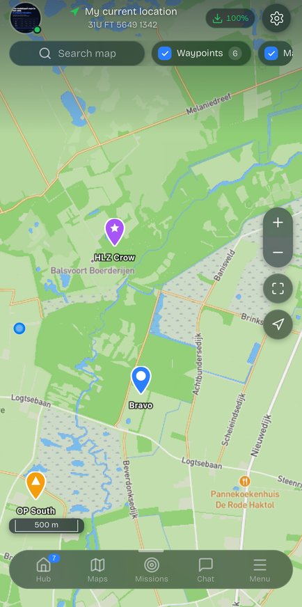
Map with MGRS grid
Your position, waypoints and the MGRS coordinate of the point under your finger.
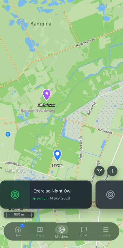
Missions and waypoints
Organise points per mission, each with its own MGRS reference.
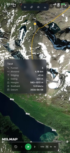
3D flyover
Review the route in 3D before you head into the terrain.
Which devices does it run on?
iPhone and iPad
iOS 15 or later, free on the App Store.
Android
Android 8.0 or later, free on Google Play.
Browser
No install needed on laptop or desktop — same account, same maps.
Frequently asked questions
Is the MGRS app really free?
Yes. The Starter plan is free and stays free: displaying, entering and converting MGRS is included, plus up to 5 maps and 1 offline region. No credit card is needed to sign up. Pro and Team are paid and add unlimited maps, missions, PDF export and terrain analysis.
Does the MGRS app work offline?
Conversion between GPS and MGRS happens locally on your device, so it always works, even without signal. For the map imagery itself you download an offline region in advance — the free plan includes one region.
What precision does the app support?
From 4-digit (10 km) down to 10-digit (1 metre). You choose how many digits to display; the default is 10-digit so you can work to the metre.
Can I convert MGRS back to GPS coordinates?
Yes, both directions. In the app and in the converter on this page you can turn an MGRS reference into latitude and longitude and back again.
Do I need an account?
Not for the converter on this site. You do need one for the app itself, so your maps and waypoints are saved and appear on your other devices. Signing up is free.
Is this only for military use?
No. MGRS is also used by search and rescue teams, fire services, hunters and mountaineers. The app is just as usable for an exercise as for a multi-day trek.
More about MGRS
What Is MGRS? The Military Grid Reference System Explained
MGRS (Military Grid Reference System) is the international military standard for positioning. Learn what MGRS is, how a coordinate is built up and why it beats GPS.
Reading MGRS Coordinates: Explained Step by Step
Learn to read an MGRS coordinate: grid zone, 100 km square, easting and northing. Includes the "read right up" principle and a worked example.
Converting MGRS to GPS (Latitude and Longitude)
Convert an MGRS coordinate to GPS coordinates (latitude and longitude, WGS84). Here is how the conversion works and how to do it automatically in MilMap.
Converting GPS to MGRS (Latitude/Longitude → MGRS)
Convert latitude and longitude to an MGRS coordinate. Here is how GPS-to-MGRS conversion works, and how to do it directly in MilMap.
Download MilMap for free
Install, sign up and start working in MGRS right away — no payment details.